


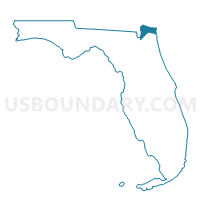
401-Voting District, Nassau County, Florida
About
Outline

Summary
| Unique Area Identifier | 556823 |
| Name | 401-Voting District |
| County | Nassau County |
| State | Florida |
| Area (square miles) | 178.50 |
| Land Area (square miles) | 177.89 |
| Water Area (square miles) | 0.61 |
| % of Land Area | 99.66 |
| % of Water Area | 0.34 |
| Latitude of the Internal Point | 30.72253220 |
| Longtitude of the Internal Point | -81.92023460 |
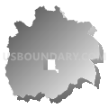
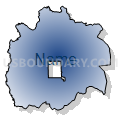
Maps


Graphs
Select a template below for downloading or customizing gragh for 401-Voting District, Nassau County, Florida


Neighbors
Neighoring Voting District (by Name) Neighboring Voting District on the Map
- 03904 - BROWNTOWN Voting District, Camden County, GA
- 0491 - FOLKSTON LIBRARY Voting District, Charlton County, GA
- 0493S - ST. GEORGE Voting District, Charlton County, GA
- 0493T - TRADERS HILL Voting District, Charlton County, GA
- 0495F - FOLKSTON FIRE STATION Voting District, Charlton County, GA
- 404-Voting District, Nassau County, FL
- 501-Voting District, Nassau County, FL
- 502-Voting District, Nassau County, FL
- 503-Voting District, Nassau County, FL
- HI-Voting District (Hilliard), Nassau County, FL
Top 10 Neighboring County Subdivision (by Population) Neighboring County Subdivision on the Map
- Yulee CCD, Nassau County, FL (26,583)
- Callahan-Hilliard CCD, Nassau County, FL (26,279)
- Kingsland CCD, Camden County, GA (12,305)
- Folkston CCD, Charlton County, GA (9,330)
- St. George CCD, Charlton County, GA (2,841)
Top 10 Neighboring Place (by Population) Neighboring Place on the Map
Top 10 Neighboring Unified School District (by Population) Neighboring Unified School District on the Map
- Nassau County School District, FL (73,314)
- Camden County School District, GA (50,513)
- Charlton County School District, GA (12,171)
Top 10 Neighboring State Legislative District Lower Chamber (by Population) Neighboring State Legislative District Lower Chamber on the Map
- State House District 12, FL (159,354)
- State House District 180, GA (54,520)
- State House District 177, GA (48,483)
Top 10 Neighboring State Legislative District Upper Chamber (by Population) Neighboring State Legislative District Upper Chamber on the Map
Top 10 Neighboring 111th Congressional District (by Population) Neighboring 111th Congressional District on the Map
Top 10 Neighboring Census Tract (by Population) Neighboring Census Tract on the Map
- Census Tract 101, Charlton County, GA (9,330)
- Census Tract 504, Nassau County, FL (9,028)
- Census Tract 103.01, Camden County, GA (7,918)
- Census Tract 503.01, Nassau County, FL (7,441)
- Census Tract 505.03, Nassau County, FL (5,955)
- Census Tract 103.02, Camden County, GA (4,387)
- Census Tract 102, Charlton County, GA (2,841)
Top 10 Neighboring 5-Digit ZIP Code Tabulation Area (by Population) Neighboring 5-Digit ZIP Code Tabulation Area on the Map
- 31548, GA (20,020)
- 32097, FL (15,616)
- 32011, FL (13,854)
- 31537, GA (10,097)
- 32046, FL (9,410)
- 31562, GA (2,177)